THE SYSTEM

A repeatable survey system for seeing change over time.

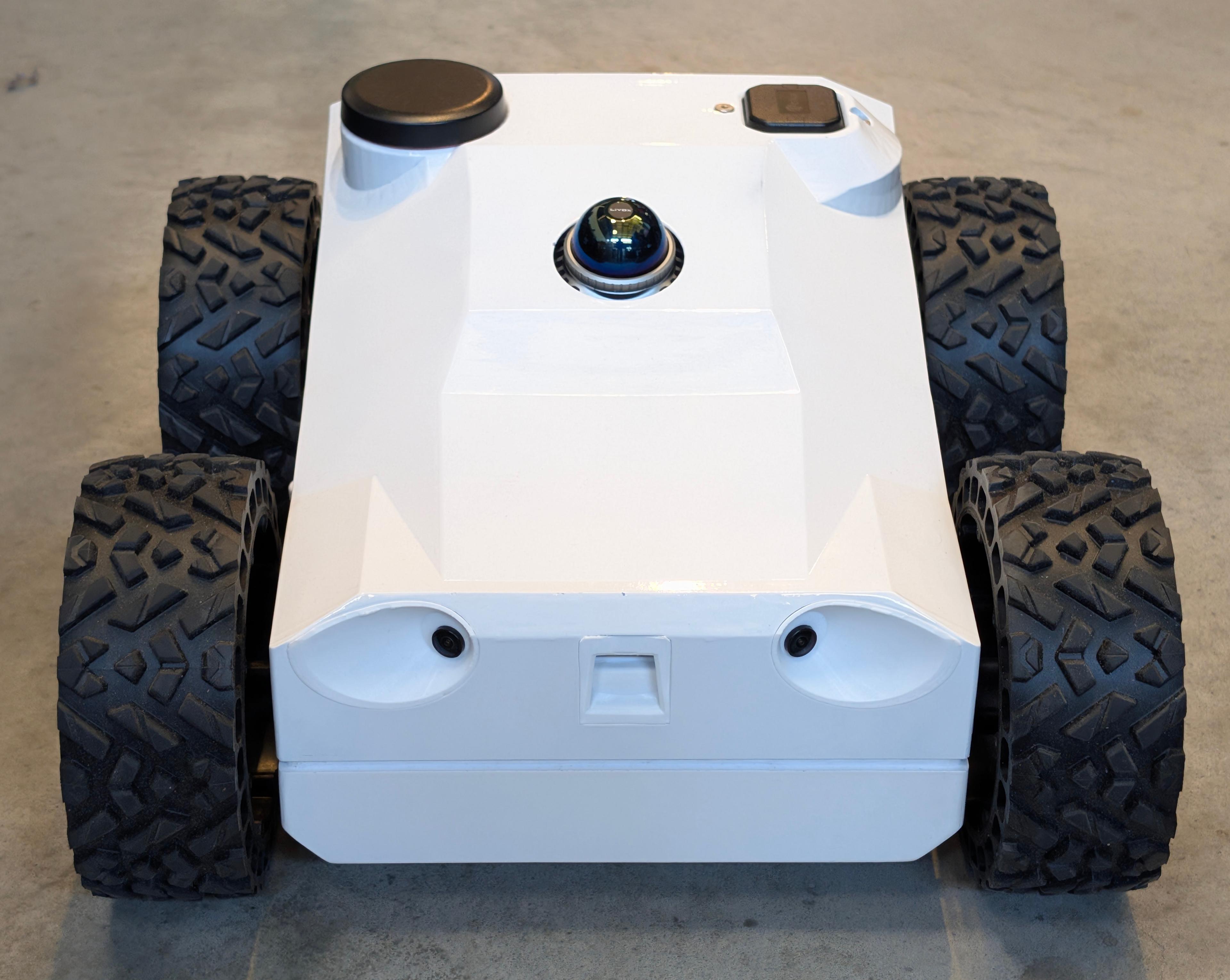
Boreal Applied is developing a robotic monitoring system that combines GPR, thermal, RGB, LiDAR, inertial sensing, and precise positioning. Designed for paved northern infrastructure, the system would repeat georeferenced surveys, align results over time, and turn located differences into traceable records for investigation and planning.

  • Working robotic foundation
  • Integrated multisensor collection
  • Repeatable georeferenced surveys
  • Traceable change records

SYSTEM ARCHITECTURE

From field collection to traceable infrastructure records.

The proposed Boreal system connects the robotic platform, multisensor payload, survey control, repeat-survey comparison, and operator outputs within one georeferenced workflow. Each layer preserves location and survey context so information can be compared over time and traced back to its supporting sensor data.

System architecture

The proposed system progresses from the Field System through Survey Operations, Analysis, and Operator Information. Analysis feedback can return to Survey Operations for localized reacquisition. The working foundation is demonstrated, while permafrost-specific interpretation and compatible third-party platform integration remain in development or planned.

  1. 01

    Field System

    • Platform: Working rover
    • Sensors: GPR, Thermal, RGB, LiDAR, IMU, GPS/RTK
    • Future integration: Compatible third-party robotic platforms

    Demonstrated foundation

    Planned integration

  2. 02

    Survey Operations

    • Mission planning
    • Route execution
    • Sensor synchronization
    • Quality assessment

    Demonstrated foundation

  3. 03

    Analysis

    • Georeference
    • Align
    • Compare
    • Trace

    Demonstrated foundation

    In development

  4. 04

    Operator Information

    • Condition maps
    • Change records
    • Reports
    • Follow-up

    In development

Quality feedback and localized reacquisition

REPEAT-SURVEY INTELLIGENCE

Return to the same asset. Isolate what changed.

A single survey provides a record of conditions at one moment. Boreal’s proposed monitoring system is designed to return to the same georeferenced area, align new information with the previous survey, and isolate differences that may require further investigation. The result is a persistent record of change rather than a series of disconnected inspections.

Survey comparison

The same paved area is surveyed twice. The baseline and current datasets are aligned, then a localized difference is connected to a Traceable Change Record.

  1. 01

    Baseline Survey

    Previous survey

    Establish a georeferenced reference survey using a planned route, synchronized sensor collection, and recorded data-quality context.

  2. 02

    Repeat Survey

    Current survey

    Return to the same asset, repeat the survey coverage, and align the new dataset with the baseline using location and spatial context.

  3. 03

    Located Difference

    Located difference
    Traceable Change Record

    Compare the aligned surveys, isolate where surface or subsurface responses differ, and connect the supporting evidence to a traceable change record.

CORE SYSTEM CAPABILITIES

The technical foundation behind repeatable monitoring.

Boreal’s working foundation combines robotic survey execution, synchronized multisensor collection, repeat-survey analysis, and traceable evidence management. These capabilities support development of the proposed monitoring system, while permafrost-specific interpretation remains subject to northern field validation.

01

Robotic Survey Execution

Plan and execute consistent coverage across accessible paved surfaces using remote operation, autonomous route following, obstacle detection and avoidance, repeat positioning, and controlled survey-lane spacing.

Supporting capabilities

  • Remote and autonomous operation
  • Mission and route planning
  • Obstacle-aware execution
  • Repeat positioning and survey coverage
  • Adaptive coverage where additional detail is required

Status

  • Demonstrated technical foundation
ObstacleAdaptive coverageStartEndpoint

02

Integrated Sensing and Positioning

Collect complementary subsurface, surface, spatial, and positioning information during the same survey while preserving the location and context of each sensor pass.

Supporting capabilities

  • GPR subsurface response
  • Thermal and RGB surface context
  • LiDAR spatial geometry
  • Inertial sensing
  • GPS/RTK positioning
  • Synchronized, georeferenced collection

Status

  • Demonstrated technical foundation
GPRThermalRGBGPS/RTKLiDARIMUSubsurface responseSpatial context

03

Repeat-Survey Alignment and Change Detection

Return to previously surveyed coordinates, align datasets from different inspections, and identify where surface or subsurface responses changed over time.

Supporting capabilities

  • Return to prior survey locations
  • Dataset alignment and co-registration
  • Surface and subsurface comparison
  • Geolocated change identification
  • Persistent inspection history

Status

  • Demonstrated general comparison capability
  • Permafrost-specific interpretation remains in development
Before alignment112233After alignment123Localized difference

04

Quality Control and Evidence Traceability

Evaluate collection quality, preserve the connection between raw sensor passes and reported findings, and convert located changes into records that support verification and follow-up.

Supporting capabilities

  • GPR coupling and collection-quality assessment
  • Localized reacquisition where additional data is required
  • Raw-data-to-finding evidence lineage
  • Geolocated supporting evidence
  • Reporting and follow-up tasks

Status

  • Quality assessment and evidence traceability demonstrated
  • Automatic localized reacquisition partially demonstrated
Insufficient qualityLocalized reacquisition1Sensor pass2Quality check3Georeferenced evidence4Traceable finding

WORKING PROOF OF CONCEPT

Real sensor evidence from a working robotic foundation.

Boreal has a physically assembled, working proof-of-concept platform that brings together autonomous survey execution, synchronized multisensor collection, georeferencing, repeat-survey alignment, change detection, and traceable reporting. The evidence below demonstrates the existing subsurface-sensing and spatial-mapping foundation behind the proposed permafrost-monitoring system.

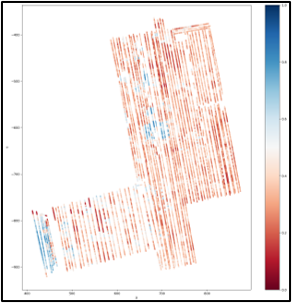
Representative GPR output from Boreal proof-of-concept testing

SUBSURFACE SENSING

Representative GPR output demonstrating the proof of concept’s ability to collect and process subsurface-response data within a georeferenced survey workflow.

Representative GPR output from proof-of-concept testing.
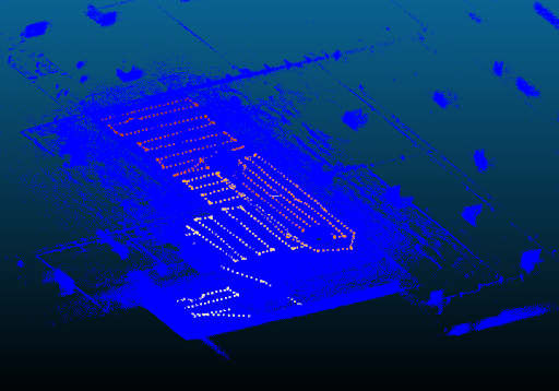
Representative LiDAR output from Boreal proof-of-concept mapping

SPATIAL MAPPING

Representative LiDAR output demonstrating the proof of concept’s ability to capture surface geometry and support spatially consistent survey mapping.

Representative LiDAR output from proof-of-concept mapping.

DEVELOPMENT PATH

From a working technical foundation to northern field validation.

Boreal’s development path begins with demonstrated robotic, sensing, and repeat-survey capabilities. The next phases adapt that foundation for permafrost monitoring and validate the resulting system through northern field testing, ground-truth comparison, and operational evaluation.

Development path from the current demonstrated robotic and multisensor foundation, through permafrost-system development, to planned northern field validation.

Current foundation

DEMONSTRATED

Demonstrated Foundation

A physically assembled working platform has demonstrated the core capabilities required for repeatable robotic inspection across accessible paved and concrete surfaces.

Established foundation

  • Remote and autonomous survey execution
  • Integrated multisensor collection
  • Georeferenced mapping
  • Repeat-survey alignment
  • General change detection
  • Traceable reporting and follow-up

IN DEVELOPMENT

Permafrost-System Development

Boreal is developing the system integration, interpretation workflows, quality controls, and decision-support outputs required to apply the existing technical foundation to changing ground beneath northern infrastructure.

Development focus

  • Sensor integration and calibration
  • Permafrost-monitoring workflow
  • Repeat-survey interpretation
  • Data-quality and reacquisition logic
  • Traceable Change Records
  • Canadian engineering, testing, and data processing

PLANNED VALIDATION

Northern Field Validation

The proposed system will require testing at suitable northern paved assets and comparison with appropriate ground-truth measurements before permafrost-specific performance claims can be established.

Validation focus

  • Above-freezing northern field surveys
  • Repeated surveys of the same asset
  • Ground-truth comparison
  • Repeatability and limitation assessment
  • Operator review of outputs
  • Pilot and field-program development

WORK WITH BOREAL

Explore a pilot or northern field-validation program.

If your organization manages paved infrastructure affected by changing ground conditions, talk with Boreal about site requirements, validation objectives, system integration, or an R&D collaboration.